
Faire un don
Équipez-vous pour votre prochaine aventure :
En tant que Partenaire Amazon, ce site perçoit une commission sur les achats éligibles sans surcoût pour vous.
Carte topographique Uasin Gishu County
Cliquez sur la carte pour afficher l’altitude.
Faire un don
Équipez-vous pour votre prochaine aventure :
En tant que Partenaire Amazon, ce site perçoit une commission sur les achats éligibles sans surcoût pour vous.
Uasin Gishu County
Uasin Gishu County is one of the 47 counties of Kenya located in the former Rift Valley Province. Eldoret has the county's largest population centre as well as its administrative and commercial centre. “It lies between longitudes 34 degrees 50’ east and 35 degrees 37’ West and latitudes 0 degrees 03’ South and 0 degrees 55’ North. It is a highland plateau with altitudes falling gently from 2,700 meters above sea level to about 1,500 meters above sea level. The topography is higher to the east and declines gently towards the western border”.
Faire un don
Équipez-vous pour votre prochaine aventure :
En tant que Partenaire Amazon, ce site perçoit une commission sur les achats éligibles sans surcoût pour vous.
À propos de cette carte
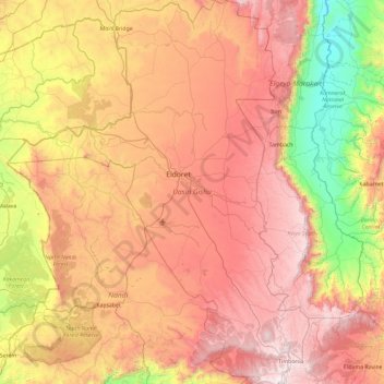
Nom : Carte topographique Uasin Gishu County, altitude, relief.
Lieu : Uasin Gishu County, Kenya (0.00649 34.85349 0.94350 35.59131)
Altitude moyenne : 1 933 m
Altitude minimum : 1 007 m
Altitude maximum : 2 886 m
Faire un don
Équipez-vous pour votre prochaine aventure :
En tant que Partenaire Amazon, ce site perçoit une commission sur les achats éligibles sans surcoût pour vous.
Autres cartes topographiques
Cliquez sur une carte pour visualiser sa topographie, son altitude et son relief.
Faire un don
Équipez-vous pour votre prochaine aventure :
En tant que Partenaire Amazon, ce site perçoit une commission sur les achats éligibles sans surcoût pour vous.
Sleeping Warrior (Delamare's Nose)
Kenya > Nakuru > Gilgil > Mbaruk/Eburu ward > Ututu
Altitude moyenne : 1 850 m
Faire un don
Équipez-vous pour votre prochaine aventure :
En tant que Partenaire Amazon, ce site perçoit une commission sur les achats éligibles sans surcoût pour vous.
Faire un don
Équipez-vous pour votre prochaine aventure :
En tant que Partenaire Amazon, ce site perçoit une commission sur les achats éligibles sans surcoût pour vous.
Mombasa
Kenya > Mombasa County > Mvita
Being a coastal town, Mombasa is characterised by a flat topography. The town of Mombasa is centred on Mombasa Island, but extends to the mainland. The island is separated from the mainland by two creeks, Port Reitz in the south and Tudor Creek in the north.
Altitude moyenne : 32 m
Faire un don
Équipez-vous pour votre prochaine aventure :
En tant que Partenaire Amazon, ce site perçoit une commission sur les achats éligibles sans surcoût pour vous.
Faire un don
Équipez-vous pour votre prochaine aventure :
En tant que Partenaire Amazon, ce site perçoit une commission sur les achats éligibles sans surcoût pour vous.
Faire un don
Équipez-vous pour votre prochaine aventure :
En tant que Partenaire Amazon, ce site perçoit une commission sur les achats éligibles sans surcoût pour vous.
Nakuru
Kenya > Nakuru > Nakuru West
On 3 June 2021, Nakuru was officially endorsed for city status after the Kenyan Senate voted for its elevation from a municipality. Following the approval of the Senate of Kenya in June, the President of the Republic of Kenya gave a city charter for official transformation of Nakuru to a city status in…
Altitude moyenne : 1 921 m