
Carte topographique Town of Kentville
Carte interactive
Cliquez sur la carte pour afficher l’altitude.
À propos de cette carte
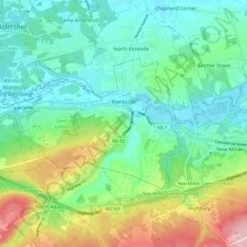
Nom : Carte topographique Town of Kentville, altitude, relief.
Altitude moyenne : 64 m
Altitude minimum : 1 m
Altitude maximum : 216 m
Autres cartes topographiques
Cliquez sur une carte pour visualiser sa topographie, son altitude et son relief.
Woodville
Canada > Nova Scotia > Kings County > Woodville
Woodville, Municipality of the County of Kings, Kings County, Nova Scotia, B0P 1V0, Canada
Altitude moyenne : 54 m