
Carte topographique Salatiga
Carte interactive
Cliquez sur la carte pour afficher l’altitude.
Salatiga
Salatiga is located 48 km (30 mi) south of Semarang and 54 km (34 mi) north of Surakarta. Its elevation is between 450–800 metres. Salatiga has a tropical monsoon climate (Am) in the Köppen climate classification with the average rainfall of 2,668 mm (105.0 in) per year, the highest temperature in October (24.1 °C) and the lowest in January (22.4 °C).
À propos de cette carte
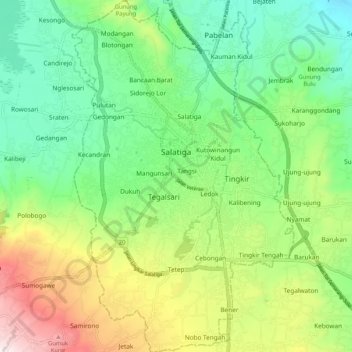
Nom : Carte topographique Salatiga, altitude, relief.
Lieu : Salatiga, Central Java, Java, Indonesia (-7.38882 110.46876 -7.28596 110.53443)
Altitude moyenne : 625 m
Altitude minimum : 360 m
Altitude maximum : 1 133 m
Autres cartes topographiques
Cliquez sur une carte pour visualiser sa topographie, son altitude et son relief.