
Faire un don
Équipez-vous pour votre prochaine aventure :
En tant que Partenaire Amazon, ce site perçoit une commission sur les achats éligibles sans surcoût pour vous.
Carte topographique Shimshal
Cliquez sur la carte pour afficher l’altitude.
Faire un don
Équipez-vous pour votre prochaine aventure :
En tant que Partenaire Amazon, ce site perçoit une commission sur les achats éligibles sans surcoût pour vous.
À propos de cette carte
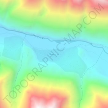
Nom : Carte topographique Shimshal, altitude, relief.
Lieu : Shimshal, Hunza District, Gilgit-Baltistan, Pakistan (36.41750 75.29668 36.45750 75.33668)
Altitude moyenne : 3 514 m
Altitude minimum : 3 039 m
Altitude maximum : 4 495 m
Faire un don
Équipez-vous pour votre prochaine aventure :
En tant que Partenaire Amazon, ce site perçoit une commission sur les achats éligibles sans surcoût pour vous.
Autres cartes topographiques
Cliquez sur une carte pour visualiser sa topographie, son altitude et son relief.
Ishkoman Tehsil
Pakistan > Gilgit-Baltistan > Ghizer District
The Ishkoman (Urdu: اشکومن) valley lies in the north of Ghizer District in Gilgit-Baltistan, Pakistan. It borders Afghanistan and the Pamir Wakhan Corridor. Its altitude ranges from 7,000 to 12,000 feet (2,100 to 3,700 m) above sea level. The languages spoken here include Shina, Khowar, Brushaski and Wakhi.
Altitude moyenne : 4 324 m
Faire un don
Équipez-vous pour votre prochaine aventure :
En tant que Partenaire Amazon, ce site perçoit une commission sur les achats éligibles sans surcoût pour vous.
Faire un don
Équipez-vous pour votre prochaine aventure :
En tant que Partenaire Amazon, ce site perçoit une commission sur les achats éligibles sans surcoût pour vous.
Deosai National Park
Deosai National Park (Urdu: دیوسائی باغ ملی) is a high-altitude alpine plain and national park located between the Skardu District and Astore District in Gilgit-Baltistan, Pakistan. Lying to the east of Nanga Parbat and in the western Himalayas, close to the central Karakoram Range surrounded by…
Altitude moyenne : 4 310 m
Faire un don
Équipez-vous pour votre prochaine aventure :
En tant que Partenaire Amazon, ce site perçoit une commission sur les achats éligibles sans surcoût pour vous.
Biafo Glacier
Pakistan > Gilgit-Baltistan > Shigar District
Biafo Glacier converging at Hispar La with 49 kilometres (30 mi) long Hispar Glacier situated at an elevation of 5,128 metres (16,824 ft), forms the glacial system considered as the world's longest non-polar glacial system which spans an overall distance of around 120 kilometres (75 mi). This frozen pathway…
Altitude moyenne : 4 618 m
Faire un don
Équipez-vous pour votre prochaine aventure :
En tant que Partenaire Amazon, ce site perçoit une commission sur les achats éligibles sans surcoût pour vous.
Indus River
Pakistan > Gilgit-Baltistan > Kharmang District > Manthokha
In the uppermost, highest part of the Indus River basin there are relatively few genera and species: Diptychus, Ptychobarbus, Schizopyge, Schizopygopsis and Schizothorax snowtrout, Triplophysa loaches, and the catfish Glyptosternon reticulatum. Going downstream these are soon joined by the golden mahseer Tor…
Altitude moyenne : 2 956 m
Faire un don
Équipez-vous pour votre prochaine aventure :
En tant que Partenaire Amazon, ce site perçoit une commission sur les achats éligibles sans surcoût pour vous.
Indus River
Pakistan > Gilgit-Baltistan > Kharmang District > Manthokha
In the uppermost, highest part of the Indus River basin there are relatively few genera and species: Diptychus, Ptychobarbus, Schizopyge, Schizopygopsis and Schizothorax snowtrout, Triplophysa loaches, and the catfish Glyptosternon reticulatum. Going downstream these are soon joined by the golden mahseer Tor…
Altitude moyenne : 2 956 m
Faire un don
Équipez-vous pour votre prochaine aventure :
En tant que Partenaire Amazon, ce site perçoit une commission sur les achats éligibles sans surcoût pour vous.
Faire un don
Équipez-vous pour votre prochaine aventure :
En tant que Partenaire Amazon, ce site perçoit une commission sur les achats éligibles sans surcoût pour vous.
Faire un don
Équipez-vous pour votre prochaine aventure :
En tant que Partenaire Amazon, ce site perçoit une commission sur les achats éligibles sans surcoût pour vous.
Faire un don
Équipez-vous pour votre prochaine aventure :
En tant que Partenaire Amazon, ce site perçoit une commission sur les achats éligibles sans surcoût pour vous.
Faire un don
Équipez-vous pour votre prochaine aventure :
En tant que Partenaire Amazon, ce site perçoit une commission sur les achats éligibles sans surcoût pour vous.
Faire un don
Équipez-vous pour votre prochaine aventure :
En tant que Partenaire Amazon, ce site perçoit une commission sur les achats éligibles sans surcoût pour vous.