
Carte topographique Screven County
Carte interactive
Cliquez sur la carte pour afficher l’altitude.
À propos de cette carte
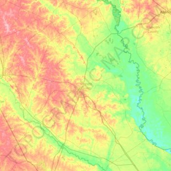
Nom : Carte topographique Screven County, altitude, relief.
Lieu : Screven County, Georgia, United States (32.48928 -81.86891 33.04558 -81.38921)
Altitude moyenne : 50 m
Altitude minimum : 4 m
Altitude maximum : 117 m
According to the U.S. Census Bureau, the county has a total area of 656 square miles (1,700 km2), of which 645 square miles (1,670 km2) is land and 11 square miles (28 km2) (1.6%) is water. The Savannah River borders the eastern side of the county, and the Ogeechee River borders the southwest portion. Elevation varies to around 40 feet on the Savannah river to 320 feet at the Bay Branch community, located a few miles west of Sylvania. Pine, oak, dogwood, and other trees prevalent to the South can be found in Screven County.
Autres cartes topographiques
Cliquez sur une carte pour visualiser sa topographie, son altitude et son relief.
Atlanta
United States > Georgia > Fulton County
Atlanta, Fulton County, Georgia, United States
Altitude moyenne : 284 m
Athens
United States > Georgia > Athens
Athens, Athens-Clarke County, Georgia, 303341458, United States
Altitude moyenne : 221 m
Savannah
United States > Georgia > Chatham County
Savannah, Chatham County, Georgia, United States
Altitude moyenne : 4 m
Brunswick
United States > Georgia > Glynn County
Brunswick, Glynn County, Georgia, United States
Altitude moyenne : 2 m
Augusta
United States > Georgia > Augusta
Augusta, Richmond County, Georgia, 30901, United States
Altitude moyenne : 90 m
Macon
United States > Georgia > Bibb County
Macon, Bibb County, Georgia, United States
Altitude moyenne : 127 m
Columbus
United States > Georgia > Muscogee County
Columbus, Muscogee County, Georgia, United States
Altitude moyenne : 130 m
Atlanta
United States > Georgia > Fulton County
Atlanta, Fulton County, Georgia, 30303, United States
Altitude moyenne : 285 m
Ellijay
United States > Georgia > Gilmer County
Ellijay, Gilmer County, Georgia, 30540, United States
Altitude moyenne : 424 m
Blue Ridge
United States > Georgia > Fannin County
Blue Ridge, Fannin County, Georgia, United States
Altitude moyenne : 535 m
Dahlonega
United States > Georgia > Lumpkin County
Dahlonega, Lumpkin County, Georgia, United States
Altitude moyenne : 411 m
Vinings
United States > Georgia > Cobb County
Vinings, Cobb County, Georgia, 30339, United States
Altitude moyenne : 281 m
Radio Springs
United States > Georgia > Floyd County
Radio Springs, Floyd County, Georgia, United States
Altitude moyenne : 243 m
Helen
United States > Georgia > White County
Helen, White County, Georgia, 30545, United States
Altitude moyenne : 488 m
Tybee Island
United States > Georgia > Chatham County
Tybee Island, Chatham County, Georgia, 31328, United States
Altitude moyenne : 1 m
Gwinnett County
Gwinnett County, Georgia, United States
Altitude moyenne : 302 m
Hiawassee
United States > Georgia > Towns County
Hiawassee, Towns County, Georgia, United States
Altitude moyenne : 620 m
Wilscot
United States > Georgia > Fannin County
Wilscot, Fannin County, Georgia, United States
Altitude moyenne : 614 m
Blairsville
United States > Georgia > Union County
Blairsville, Union County, Georgia, United States
Altitude moyenne : 587 m
Robins Air Force Base
United States > Georgia > Houston County
Robins Air Force Base, Houston County, Georgia, 31098, United States
Altitude moyenne : 92 m
Georgia International Horse Park
United States > Georgia > Rockdale County > Conyers
Georgia International Horse Park, Conyers, Rockdale County, Georgia, United States
Altitude moyenne : 209 m
Alpharetta
United States > Georgia > Fulton County
Alpharetta, Fulton County, Georgia, United States
Altitude moyenne : 324 m
Saint Simons Island
United States > Georgia > Glynn County
Saint Simons Island, Glynn County, Georgia, 31561, United States
Altitude moyenne : 2 m
Gainesville
United States > Georgia > Hall County
Gainesville, Hall County, Georgia, 30501, United States
Altitude moyenne : 346 m
Skidaway Island
United States > Georgia > Chatham County
Skidaway Island, Chatham County, Georgia, 31411, United States
Altitude moyenne : 3 m
Lumpkin
United States > Georgia > Stewart County
Lumpkin, Stewart County, Georgia, United States
Altitude moyenne : 147 m
Canton
United States > Georgia > Cherokee County
Canton, Cherokee County, Georgia, United States
Altitude moyenne : 320 m
Jointer Island
United States > Georgia > Glynn County > Brunswick
Jointer Island, Brunswick, Glynn County, Georgia, United States
Altitude moyenne : 0 m
Heritage Acres
United States > Georgia > Bibb County > Macon
Heritage Acres, Macon, Bibb County, Georgia, 31211, United States
Altitude moyenne : 119 m
Stone Mountain
United States > Georgia > DeKalb County
Stone Mountain, DeKalb County, Georgia, 30087, United States
Altitude moyenne : 299 m
Woodstock
United States > Georgia > Cherokee County
Woodstock, Cherokee County, Georgia, United States
Altitude moyenne : 296 m
Lake Oconee
United States > Georgia > Greene County > Lake Oconee
Lake Oconee, Greene County, Georgia, United States
Altitude moyenne : 165 m
Mountain City
United States > Georgia > Rabun County
Mountain City, Rabun County, Georgia, 30562, United States
Altitude moyenne : 747 m
Paulding County
Paulding County, Georgia, United States
Altitude moyenne : 311 m
Kennesaw
United States > Georgia > Cobb County
Kennesaw, Cobb County, Georgia, 30144, United States
Altitude moyenne : 317 m
Iron Mountain
United States > Georgia > Murray County
Iron Mountain, Murray County, Georgia, United States
Altitude moyenne : 362 m
Fort Pulaski
United States > Georgia > Chatham County
Fort Pulaski, Fort Perimeter Trail, Chatham County, Georgia, 31328, United States
Altitude moyenne : 1 m
Tugaloo
United States > Georgia > Habersham County > Tallulah Falls
Tugaloo, Tallulah Falls, Habersham County, Georgia, United States
Altitude moyenne : 392 m
Elmodel
United States > Georgia > Baker County
Elmodel, Baker County, Georgia, United States
Altitude moyenne : 51 m
Warner Robins
United States > Georgia > Houston County
Warner Robins, Houston County, Georgia, United States
Altitude moyenne : 101 m