
Carte topographique Wildeck
Cliquez sur la carte pour afficher l’altitude.
À propos de cette carte
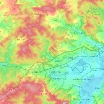
Nom : Carte topographique Wildeck, altitude, relief.
Lieu : Wildeck, Landkreis Hersfeld-Rotenburg, Hesse, 36208, Germany (50.91509 9.89623 50.99653 10.06485)
Altitude moyenne : 330 m
Altitude minimum : 208 m
Altitude maximum : 508 m
Autres cartes topographiques
Cliquez sur une carte pour visualiser sa topographie, son altitude et son relief.
Bad Hersfeld
Germany > Hesse > Landkreis Hersfeld-Rotenburg
The Flugplatz Johannesberg has the status of Special Airfield. The runway, some 671 m long and 18 m wide, is paved with asphalt and oriented in a north–south direction. The airfield lies on the Johannesberg in the like-named outlying centre at an elevation of 284 m above sea level.
Altitude moyenne : 281 m