
Carte topographique Palembang
Carte interactive
Cliquez sur la carte pour afficher l’altitude.
Palembang
At 2°59′10″S 104°45′20″E / 2.98611°S 104.75556°E / -2.98611; 104.75556, Palembang occupies 400.61 km2 of vast lowland area east of Bukit Barisan Mountains in southern Sumatra with average elevation of 8 metres (26 feet), approximately 105 kilometres (65 miles) from nearby coast at Bangka Strait. One of the largest rivers in Sumatra, the Musi River, runs through the city, dividing the city area into two major parts which are Seberang Ilir in the north and Seberang Ulu in the south. Palembang is also located on the confluence of two major tributaries of Musi River, which are Ogan River and Komering River. The river's water level is influenced by tidal cycle. In rainy season, many areas on the city are inundated by the river's tide.
À propos de cette carte
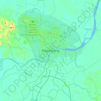
Nom : Carte topographique Palembang, altitude, relief.
Lieu : Palembang, South Sumatra, 30267, Indonesia (-3.14883 104.59686 -2.82883 104.91686)
Altitude moyenne : 6 m
Altitude minimum : 0 m
Altitude maximum : 51 m
Autres cartes topographiques
Cliquez sur une carte pour visualiser sa topographie, son altitude et son relief.