
Carte topographique Astrakhan District
Carte interactive
Cliquez sur la carte pour afficher l’altitude.
À propos de cette carte
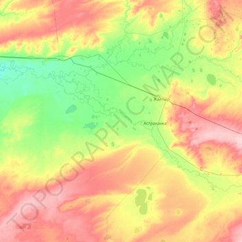
Nom : Carte topographique Astrakhan District, altitude, relief.
Lieu : Astrakhan District, Akmola Region, Kazakhstan (51.03471 68.92461 52.03475 70.44459)
Altitude moyenne : 323 m
Altitude minimum : 273 m
Altitude maximum : 408 m
Autres cartes topographiques
Cliquez sur une carte pour visualiser sa topographie, son altitude et son relief.
Kokshetau
Kazakhstan > Akmola Region > Кокшетау Г.А. > Kokshetau
Kokshetau, Кокшетау Г.А., Akmola Region, 020000, Kazakhstan
Altitude moyenne : 250 m
Korgalzhyn District
Korgalzhyn District, Akmola Region, Kazakhstan
Altitude moyenne : 346 m
Lake Tengiz
Lake Tengiz, Коргалжынский район, Akmola Region, Kazakhstan
Altitude moyenne : 318 m