
Carte topographique Chambersburg
Carte interactive
Cliquez sur la carte pour afficher l’altitude.
À propos de cette carte
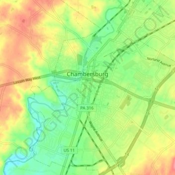
Nom : Carte topographique Chambersburg, altitude, relief.
Lieu : Chambersburg, Franklin County, Pennsylvania, United States (39.90580 -77.68568 39.96065 -77.62369)
Altitude moyenne : 200 m
Altitude minimum : 166 m
Altitude maximum : 241 m
Chambersburg is served by the Lincoln Highway, U.S. 30, between McConnellsburg and Gettysburg. U.S. 11, the Molly Pitcher Highway, passes through it between Shippensburg, Pennsylvania, and Hagerstown, Maryland. Interstate 81 skirts the borough to its east. The town lies approximately midpoint on US Route 30 between Pittsburgh and Philadelphia. The local topography reflects both flatter areas like Philadelphia and mountainous areas like Pittsburgh. Downtown Chambersburg has occasional events such as Food Truck Festival and Apple Fest.
Autres cartes topographiques
Cliquez sur une carte pour visualiser sa topographie, son altitude et son relief.
Waynesboro
United States > Pennsylvania > Franklin County
Waynesboro, Franklin County, Pennsylvania, United States
Altitude moyenne : 210 m