
Carte topographique Ostroszowice
Carte interactive
Cliquez sur la carte pour afficher l’altitude.
À propos de cette carte
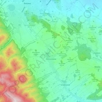
Nom : Carte topographique Ostroszowice, altitude, relief.
Altitude moyenne : 415 m
Altitude minimum : 280 m
Altitude maximum : 818 m
Autres cartes topographiques
Cliquez sur une carte pour visualiser sa topographie, son altitude et son relief.
Jodłownik
Poland > Lower Silesian Voivodeship > Dzierżoniów County > Ostroszowice
Jodłownik, Ostroszowice, gmina Dzierżoniów, Dzierżoniów County, Lower Silesian Voivodeship, Poland
Altitude moyenne : 445 m
Czernica
Poland > Lower Silesian Voivodeship > Dzierżoniów County > Jaźwina
Czernica, Jaźwina, gmina Łagiewniki, Dzierżoniów County, Lower Silesian Voivodeship, 58-212, Poland
Altitude moyenne : 361 m
Pieszyce
Poland > Lower Silesian Voivodeship > Dzierżoniów County
Pieszyce, gmina Pieszyce, Dzierżoniów County, Lower Silesian Voivodeship, Poland
Altitude moyenne : 337 m