
Carte topographique Niksar
Carte interactive
Cliquez sur la carte pour afficher l’altitude.
À propos de cette carte
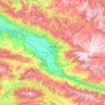
Nom : Carte topographique Niksar, altitude, relief.
Lieu : Niksar, Tokat, Black Sea Region, 60600, Turkey (40.38944 36.67206 40.74426 37.24789)
Altitude moyenne : 1 009 m
Altitude minimum : 213 m
Altitude maximum : 1 823 m
Niksar is approximately 9,555 km2 (3,689 sq mi). It is located at 40°35' north latitude and 36°58' east longitude. Its average altitude is 350m above sea level. It is surrounded by Erbaa on the northwest, Tokat on the southwest, Almus on the south, Başçiftlik on the southeast and Akkuş on the north. It is one of the five largest counties of Tokat. The Canik Mountains are to the north, Dönek Mountain to the south, and the Niksar Lowland is situated between these mountains. The Niksar Lowland is one of the most important lowlands of the Black Sea Region. The Canik Mountains are covered with plateaus that lie parallel to the Black Sea. Çamiçi High Plateau is one of the most important ones.
Autres cartes topographiques
Cliquez sur une carte pour visualiser sa topographie, son altitude et son relief.
Çamlıca Mahallesi
Turkey > Tokat > Reşadiye > Reşadiye Belediyesi
Çamlıca Mahallesi, Reşadiye Belediyesi, Reşadiye, Tokat, Black Sea Region, Turkey
Altitude moyenne : 612 m
Çerçi
Turkey > Tokat > Tokat Merkez
Çerçi, Tokat Merkez, Tokat, Black Sea Region, Turkey
Altitude moyenne : 616 m