
Carte topographique Assum
Carte interactive
Cliquez sur la carte pour afficher l’altitude.
À propos de cette carte
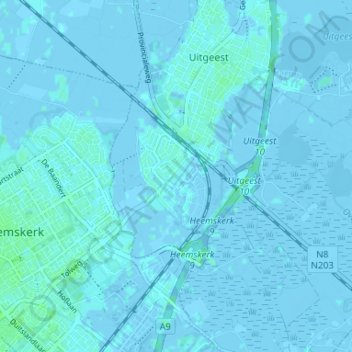
Nom : Carte topographique Assum, altitude, relief.
Lieu : Assum, Uitgeest, Noord-Holland, Nederland, 1911 MD, Nederland (52.49678 4.68297 52.53678 4.72297)
Altitude moyenne : 0 m
Altitude minimum : -6 m
Altitude maximum : 5 m
Autres cartes topographiques
Cliquez sur une carte pour visualiser sa topographie, son altitude et son relief.
Uitgeest
Nederland > Noord-Holland > Uitgeest
Uitgeest, Noord-Holland, Nederland
Altitude moyenne : -1 m
Limmerkoog
Nederland > Noord-Holland > Uitgeest > Limmerkoog
Limmerkoog, Uitgeest, Noord-Holland, Nederland, 1902, Nederland
Altitude moyenne : 0 m
Fort bij Krommeniedijk
Nederland > Noord-Holland > Uitgeest
Fort bij Krommeniedijk, Krommenieweg, Uitgeest, Noord-Holland, Nederland, 1562GT, Nederland
Altitude moyenne : -1 m