
Carte topographique Cloudland Canyon State Park
Carte interactive
Cliquez sur la carte pour afficher l’altitude.
À propos de cette carte
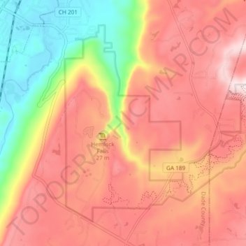
Nom : Carte topographique Cloudland Canyon State Park, altitude, relief.
Altitude moyenne : 488 m
Altitude minimum : 210 m
Altitude maximum : 681 m
Cloudland Canyon State Park is a 3,485 acres (14.10 km2) Georgia state park located near Trenton and Cooper Heights on the western edge of Lookout Mountain. One of the largest and most scenic parks in Georgia, it contains rugged geology, and offers visitors a range of vistas across the deep gorge cut through the mountain by Sitton Gulch Creek, where the elevation varies from 800 to over 1,800 feet. Views of the canyon can be seen from the picnic area parking lot, in addition to additional views located along the rim trail. At the bottom of the gorge, two waterfalls cascade across layers of sandstone and shale, ending in small pools below.
Autres cartes topographiques
Cliquez sur une carte pour visualiser sa topographie, son altitude et son relief.
Trenton
United States > Georgia > Dade County
Trenton, Dade County, Georgia, United States
Altitude moyenne : 280 m
West Brow
United States > Georgia > Dade County
West Brow, Dade County, Georgia, 30757, United States
Altitude moyenne : 426 m
Head River
United States > Georgia > Dade County
Head River, Dade County, Georgia, United States
Altitude moyenne : 585 m
Cole City
United States > Georgia > Dade County
Cole City, Dade County, Georgia, United States
Altitude moyenne : 431 m
Rising Fawn
United States > Georgia > Dade County
Rising Fawn, Dade County, Georgia, United States
Altitude moyenne : 314 m
Wildwood
United States > Georgia > Dade County
Wildwood, Dade County, Georgia, 30757, United States
Altitude moyenne : 258 m
New England
United States > Georgia > Dade County
New England, Dade County, Georgia, United States
Altitude moyenne : 242 m
New England
United States > Georgia > Dade County
New England, Dade County, Georgia, 30752, United States
Altitude moyenne : 257 m
Trenton
United States > Georgia > Dade County
Trenton, Dade County, Georgia, United States
Altitude moyenne : 280 m
Cole City
United States > Georgia > Dade County
Cole City, Dade County, Georgia, United States
Altitude moyenne : 417 m