Géolocaliser

Carte topographique East Garo Hills

Carte interactive

Cliquez sur la carte pour afficher l’altitude.

À propos de cette carte

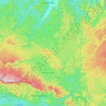
Nom : Carte topographique East Garo Hills, altitude, relief.

Lieu : East Garo Hills, Meghalaya, 783122, Inde (25.41575 90.31611 25.81983 90.98234)

Altitude moyenne : 389 m

Altitude minimum : 27 m

Altitude maximum : 1 400 m

Autres cartes topographiques

Cliquez sur une carte pour visualiser sa topographie, son altitude et son relief.

Mawsynram

Inde > Meghalaya > Mawsynram

Mawsynram, East Khasi Hills, Meghalaya, Inde

Altitude moyenne : 1 107 m

Umling

Inde > Meghalaya > Umling

Umling, Ri-Bhoi, Meghalaya, Inde

Altitude moyenne : 472 m

West Jaintia Hills

Inde > Meghalaya

West Jaintia Hills, Meghalaya, Inde

Altitude moyenne : 933 m

Nongriat

Inde > Meghalaya > Nongriat

Nongriat, Shella Bholaganj, East Khasi Hills, Meghalaya, 793015, Inde

Altitude moyenne : 706 m

Jaintia Hills

Inde > Meghalaya

Jaintia Hills, West Jaintia Hills District, Meghalaya, Inde

Altitude moyenne : 534 m