
Faire un don
Équipez-vous pour votre prochaine aventure :
En tant que Partenaire Amazon, ce site perçoit une commission sur les achats éligibles sans surcoût pour vous.
Carte topographique San Narciso
Cliquez sur la carte pour afficher l’altitude.
Faire un don
Équipez-vous pour votre prochaine aventure :
En tant que Partenaire Amazon, ce site perçoit une commission sur les achats éligibles sans surcoût pour vous.
San Narciso
San Narciso is located in a relatively flat plain. West of the town is the South China Sea and to the east is bordered by the Sto. Tomas river are the Zambales Mountain Ranges. Average elevation is 3.6 metres (12 ft) above sea level and the highest elevation is 800 metres (2,600 ft) above sea level.
Faire un don
Équipez-vous pour votre prochaine aventure :
En tant que Partenaire Amazon, ce site perçoit une commission sur les achats éligibles sans surcoût pour vous.
À propos de cette carte
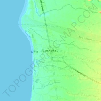
Nom : Carte topographique San Narciso, altitude, relief.
Lieu : San Narciso, Zambales, Central Luzon, 2205, Philippines (14.97552 120.03937 15.05552 120.11937)
Altitude moyenne : 11 m
Altitude minimum : 0 m
Altitude maximum : 43 m
Faire un don
Équipez-vous pour votre prochaine aventure :
En tant que Partenaire Amazon, ce site perçoit une commission sur les achats éligibles sans surcoût pour vous.