
Carte topographique Irapuato
Carte interactive
Cliquez sur la carte pour afficher l’altitude.
À propos de cette carte
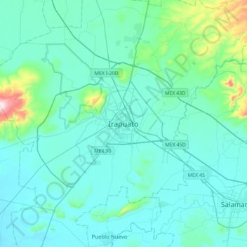
Nom : Carte topographique Irapuato, altitude, relief.
Lieu : Irapuato, Guanajuato, 36500, Mexico (20.51588 -101.51211 20.83588 -101.19211)
Altitude moyenne : 1 763 m
Altitude minimum : 1 691 m
Altitude maximum : 2 345 m
It has a humid subtropical climate (Cwa in the Köppen climate classification) with an average temperature of 20 °C (68 °F). The large majority of rainfall occurs from June - September. It is at an altitude above sea level of 1,724 meters (5,656 ft).