Géolocaliser

Carte topographique The Height

Cliquez sur la carte pour afficher l’altitude.

À propos de cette carte
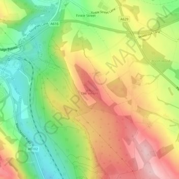
Nom : Carte topographique The Height, altitude, relief.

Lieu : The Height, Barnsley, Yorkshire and the Humber, England, S35 7DH, United Kingdom (53.47548 -1.54432 53.47558 -1.54422)

Altitude moyenne : 216 m

Altitude minimum : 118 m

Altitude maximum : 316 m

Autres cartes topographiques

Cliquez sur une carte pour visualiser sa topographie, son altitude et son relief.

Locke Park

United Kingdom > England > Barnsley > Gilroyd

Altitude moyenne : 119 m

Thurgoland

United Kingdom > England > Barnsley

Altitude moyenne : 187 m

Langsett

United Kingdom > England > Barnsley

Altitude moyenne : 329 m

Oxspring

United Kingdom > England > Barnsley

Altitude moyenne : 218 m

Cawthorne

United Kingdom > England > Barnsley

Altitude moyenne : 124 m

Barugh Green

United Kingdom > England > Barnsley

Altitude moyenne : 85 m

Higham

United Kingdom > England > Barnsley

Altitude moyenne : 120 m

Shafton

United Kingdom > England > Barnsley

Shafton lies to the north of Shafton Two Gates, on the road to Ryhill. It is located at approximately 53° 35' 10" North, 1° 24' West, at an elevation of around 262 feet (80 m) above sea level. Sceptun in the Domesday Book of 1086 then later in c. 1160 Scaftona meaning a farmstead marked by a pole, or made…

Altitude moyenne : 65 m

Stainborough

United Kingdom > England > Barnsley

Altitude moyenne : 111 m

High Hoyland

United Kingdom > England > Barnsley

High Hoyland is a village and civil parish in the Metropolitan Borough of Barnsley in South Yorkshire, England, on the border with West Yorkshire. It lies to the west of Kexbrough, and is located at approximately 53°35′10″N 1°35′30″W / 53.58611°N 1.59167°W / 53.58611; -1.59167, at an…

Altitude moyenne : 139 m

Billingley

United Kingdom > England > Barnsley

Altitude moyenne : 36 m

Équipez-vous pour votre prochaine aventure :

🧤Gants de Randonnée Tactiles - Gardez vos mains au chaud tout en utilisant votre GPS
🪙Couverture de Survie - Protection thermique d'urgence indispensable
🧭Navigation outdoor - Équipements pour s’orienter en pleine nature
📊Altimètres numériques - Mesure précise de l’altitude en temps réel
🎒Sac à Dos 30 Litres - Volume idéal pour une journée d'exploration topographique

En tant que Partenaire Amazon, ce site perçoit une commission sur les achats éligibles sans surcoût pour vous.