
Faire un don
Équipez-vous pour votre prochaine aventure :
En tant que Partenaire Amazon, ce site perçoit une commission sur les achats éligibles sans surcoût pour vous.
Carte topographique Sorsogon City
Cliquez sur la carte pour afficher l’altitude.
Faire un don
Équipez-vous pour votre prochaine aventure :
En tant que Partenaire Amazon, ce site perçoit une commission sur les achats éligibles sans surcoût pour vous.
Sorsogon City
Sorsogon City covers a land area of 31,292 hectares (120.82 sq mi). It is at the southernmost tip of the Bicol Peninsula and of Luzon Island. The city is bounded by Castilla in the west, Manito in the northwest, Albay Gulf in the north, Prieto Diaz in the east, Gubat in the southeast, Casiguran in the southwest, and Sorsogon Bay in the south. Sorsogon is characterized by an irregular topography; mountain ranges on the north-west, sloping uplands on the central part of the city, plain areas southwestern and central north and southeast portion, and marshlands on the southeast deltas. It is also surrounded by water, with Sorsogon Bay to the west Albay Gulf to the northeast, and Philippine Sea in the east.
Faire un don
Équipez-vous pour votre prochaine aventure :
En tant que Partenaire Amazon, ce site perçoit une commission sur les achats éligibles sans surcoût pour vous.
À propos de cette carte
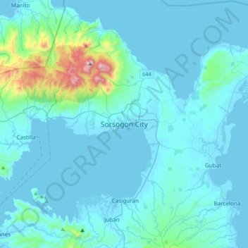
Nom : Carte topographique Sorsogon City, altitude, relief.
Lieu : Sorsogon City, Sorsogon, Bicol Region, 4700, Philippines (12.81078 123.84525 13.13078 124.16525)
Altitude moyenne : 89 m
Altitude minimum : -3 m
Altitude maximum : 1 064 m
Faire un don
Équipez-vous pour votre prochaine aventure :
En tant que Partenaire Amazon, ce site perçoit une commission sur les achats éligibles sans surcoût pour vous.
Autres cartes topographiques
Cliquez sur une carte pour visualiser sa topographie, son altitude et son relief.
Faire un don
Équipez-vous pour votre prochaine aventure :
En tant que Partenaire Amazon, ce site perçoit une commission sur les achats éligibles sans surcoût pour vous.
Bulusan Lake
Philippines > Sorsogon > San Roque
Lake Bulusan is a lake on Luzon Island in the Philippines. It lies at the heart of Bulusan Volcano National Park which covers a land area of 3,672 hectares (9,070 acres). It has an elevation of 360 metres (1,180 ft) and is located on the southeast flank of Mount Bulusan, an active volcano.
Altitude moyenne : 382 m
Faire un don
Équipez-vous pour votre prochaine aventure :
En tant que Partenaire Amazon, ce site perçoit une commission sur les achats éligibles sans surcoût pour vous.