
Carte topographique Terracina
Carte interactive
Cliquez sur la carte pour afficher l’altitude.
Terracina
Above the town are several massive terrace platforms for supporting buildings; these may well belong to the Roman period, and the latter even to the Empire. The summit of the promontory, elevation 227 metres (745 ft), is reached by the old line of the Via Appia, which is flanked by tombs and by remains of an ancient defensive wall with circular towers, the so-called Cinta Sillana (once attributed to Theodoric, but dating from the first decades of the 1st century BCE). The summit is occupied by a large terrace, supported by arcades of fine opus incertum (traditionally, but wrongly, called the "palace of Theodoric") on all sides except the east, with views seaward over the coast and over the Pontine Marshes.
À propos de cette carte
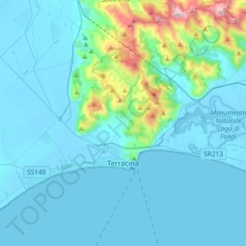
Nom : Carte topographique Terracina, altitude, relief.
Lieu : Terracina, Latina, Lazio, Italy (41.25845 13.06086 41.37844 13.31369)
Altitude moyenne : 121 m
Altitude minimum : -4 m
Altitude maximum : 1 066 m
Autres cartes topographiques
Cliquez sur une carte pour visualiser sa topographie, son altitude et son relief.