Géolocaliser

Carte topographique Lengyeltóti

Carte interactive

Cliquez sur la carte pour afficher l’altitude.

À propos de cette carte

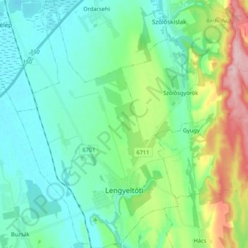
Nom : Carte topographique Lengyeltóti, altitude, relief.

Lieu : Lengyeltóti, Fonyódi járás, Somogy, Southern Transdanubia, Transdanubia, 8693, Hungary (46.64279 17.57524 46.74685 17.67420)

Altitude moyenne : 148 m

Altitude minimum : 100 m

Altitude maximum : 298 m

Autres cartes topographiques

Cliquez sur une carte pour visualiser sa topographie, son altitude et son relief.

Kaposvár

Hungary > Somogy

Kaposvár, Kaposvári járás, Somogy, Southern Transdanubia, Transdanubia, Hungary

Altitude moyenne : 162 m

Vörs

Hungary > Somogy

Vörs, Marcali járás, Somogy, Southern Transdanubia, Transdanubia, 8711, Hungary

Altitude moyenne : 117 m

Barcs

Hungary > Somogy > Barcs > Barcs

Barcs, Barcsi járás, Somogy, Southern Transdanubia, Transdanubia, 7570, Hungary

Altitude moyenne : 111 m

Siófok

Hungary > Somogy > Siófok > Siófok

Siófok, Siófoki járás, Somogy, Southern Transdanubia, Transdanubia, 8600, Hungary

Altitude moyenne : 110 m

Siófok

Hungary > Somogy

Siófok, Siófoki járás, Somogy, Southern Transdanubia, Transdanubia, Hungary

Altitude moyenne : 121 m

Barcsi járás

Hungary > Somogy

Barcsi járás, Somogy, Southern Transdanubia, Transdanubia, Hungary

Altitude moyenne : 128 m

Barcs

Hungary > Somogy

Barcs, Barcsi járás, Somogy, Southern Transdanubia, Transdanubia, Hungary

Altitude moyenne : 118 m