
Faire un don
Équipez-vous pour votre prochaine aventure :
En tant que Partenaire Amazon, ce site perçoit une commission sur les achats éligibles sans surcoût pour vous.
Carte topographique Mount Arayat
Cliquez sur la carte pour afficher l’altitude.
Faire un don
Équipez-vous pour votre prochaine aventure :
En tant que Partenaire Amazon, ce site perçoit une commission sur les achats éligibles sans surcoût pour vous.
Mount Arayat
Mount Arayat stands in the middle of the flat Central Luzon Plain, consisting of rice paddies and a typical elevation of about 15 to 35 metres MSL. The mountain is topped by a circular volcanic crater about 1.2 kilometres (0.75 mi) in diameter, much of which has collapsed on the western and part of the northern rim due to erosion. This has resulted in a breached crater which opens in a west-northwest direction. This area is the apparent source of a major debris-avalanche deposit that forms hummocky terrain beyond the west and northwest sides of the volcano. The 1,026-metre (3,366 ft) summit stands on the northeast side of the breached crater, known as North Peak, while the 984-metre (3,228 ft) Pinnacle Peak is located on the southeast crater rim. Post-collapse activity formed an andesitic lava dome known as White Rock in the collapse amphitheater.
Faire un don
Équipez-vous pour votre prochaine aventure :
En tant que Partenaire Amazon, ce site perçoit une commission sur les achats éligibles sans surcoût pour vous.
À propos de cette carte
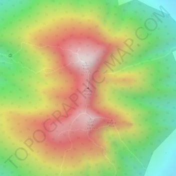
Nom : Carte topographique Mount Arayat, altitude, relief.
Altitude moyenne : 639 m
Altitude minimum : 246 m
Altitude maximum : 995 m
Faire un don
Équipez-vous pour votre prochaine aventure :
En tant que Partenaire Amazon, ce site perçoit une commission sur les achats éligibles sans surcoût pour vous.
Autres cartes topographiques
Cliquez sur une carte pour visualiser sa topographie, son altitude et son relief.