
Carte topographique Nandlstadt
Carte interactive
Cliquez sur la carte pour afficher l’altitude.
À propos de cette carte
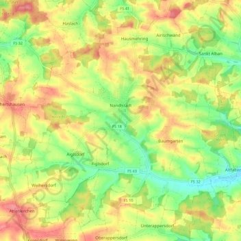
Nom : Carte topographique Nandlstadt, altitude, relief.
Lieu : Nandlstadt, Landkreis Freising, Bavaria, 85405, Germany (48.50111 11.76120 48.56388 11.86896)
Altitude moyenne : 485 m
Altitude minimum : 440 m
Altitude maximum : 528 m
Autres cartes topographiques
Cliquez sur une carte pour visualiser sa topographie, son altitude et son relief.
Zolling
Germany > Bavaria > Landkreis Freising
Zolling, Zolling (VGem), Landkreis Freising, Bavaria, 85406, Germany
Altitude moyenne : 472 m
Freising
Germany > Bavaria > Landkreis Freising
Freising, Landkreis Freising, Bavaria, Germany
Altitude moyenne : 457 m