
Faire un don
Équipez-vous pour votre prochaine aventure :
En tant que Partenaire Amazon, ce site perçoit une commission sur les achats éligibles sans surcoût pour vous.
Carte topographique Borstel-Hohenraden
Cliquez sur la carte pour afficher l’altitude.
Faire un don
Équipez-vous pour votre prochaine aventure :
En tant que Partenaire Amazon, ce site perçoit une commission sur les achats éligibles sans surcoût pour vous.
Borstel-Hohenraden
On the origin and meaning of the name: "Tho the Borstelde" in "Kerspell Rellinghen" clearly indicate our Borstel. Over the centuries, the name of Borstelde over Borstele, Borstell, Borsteler altered, Barstell to Borstel (the Urdorf). Originally, the name comes from the Old Saxon "bur" = home and "Stal" = location facility. The name can be found very often, not only in Schleswig-Holstein, but also in Hamburg and Lower Saxony. The name of the daughter of the village Hohenraden indicates a later scale of Borstelern cleared area. Yet 1688 is this place called "the Hohenrade" and only in the 19th century. Is the place name Hohenraden. Rade (Rode) means clearing, so the high-altitude clearance. It was also suggested that it was the settlement that was only with the "high wheel" available. Structurally, the municipality Borstel-Hohenraden has developed in recent years from a farming village into a residential community. The aim is to preserve the functions of housing and agriculture alike. The community is faced with the task of infrastructural measures to improve the quality of living for the people living in the municipality inhabitants constantly.
Faire un don
Équipez-vous pour votre prochaine aventure :
En tant que Partenaire Amazon, ce site perçoit une commission sur les achats éligibles sans surcoût pour vous.
À propos de cette carte
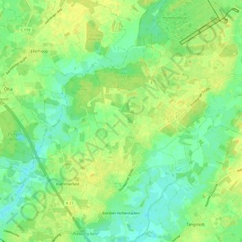
Nom : Carte topographique Borstel-Hohenraden, altitude, relief.
Altitude moyenne : 12 m
Altitude minimum : 1 m
Altitude maximum : 22 m
Faire un don
Équipez-vous pour votre prochaine aventure :
En tant que Partenaire Amazon, ce site perçoit une commission sur les achats éligibles sans surcoût pour vous.
Autres cartes topographiques
Cliquez sur une carte pour visualiser sa topographie, son altitude et son relief.