
Carte topographique Holzhäuseln
Carte interactive
Cliquez sur la carte pour afficher l’altitude.
À propos de cette carte
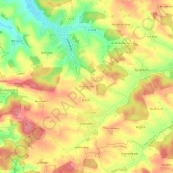
Nom : Carte topographique Holzhäuseln, altitude, relief.
Altitude moyenne : 486 m
Altitude minimum : 431 m
Altitude maximum : 523 m
Autres cartes topographiques
Cliquez sur une carte pour visualiser sa topographie, son altitude et son relief.
Freidling
Deutschland > Bayern > Landkreis Landshut > Buch am Erlbach
Freidling, Buch am Erlbach, Landkreis Landshut, Bayern, 84172, Deutschland
Altitude moyenne : 486 m
Holzen
Deutschland > Bayern > Landkreis Landshut > Buch am Erlbach
Holzen, Buch am Erlbach, Landkreis Landshut, Bayern, 84434, Deutschland
Altitude moyenne : 488 m