
Carte topographique Berwick-upon-Tweed
Carte interactive
Cliquez sur la carte pour afficher l’altitude.
À propos de cette carte
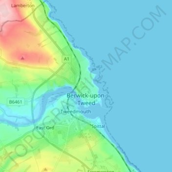
Nom : Carte topographique Berwick-upon-Tweed, altitude, relief.
Altitude moyenne : 33 m
Altitude minimum : -1 m
Altitude maximum : 197 m
In the 1840s, Samuel Lewis included similar entries for Berwick-upon-Tweed in both his England and Scotland Topographical Dictionary. Berwick remained a county in its own right, and was not included in Northumberland for Parliamentary purposes until 1885. In the same year, the Redistribution of Seats Act reduced the number of Members of Parliament (MPs) returned by the town from two to one.
Autres cartes topographiques
Cliquez sur une carte pour visualiser sa topographie, son altitude et son relief.
West Learmouth
United Kingdom > England > Northumberland > Carham
West Learmouth, Carham, Northumberland, North of Tyne, England, TD12 4RB, United Kingdom
Altitude moyenne : 44 m
Ponteland
United Kingdom > England > Northumberland
Ponteland, Northumberland, North of Tyne, England, United Kingdom
Altitude moyenne : 76 m
Rothbury
United Kingdom > England > Northumberland
Rothbury, Northumberland, North of Tyne, England, United Kingdom
Altitude moyenne : 176 m
Chillingham
United Kingdom > England > Northumberland
Chillingham, Northumberland, North of Tyne, England, United Kingdom
Altitude moyenne : 115 m
Whiteadder Water
United Kingdom > England > Northumberland > Berwick-upon-Tweed > Newmills
Whiteadder Water, Newmills, Berwick-upon-Tweed, Northumberland, North of Tyne, England, United Kingdom
Altitude moyenne : 29 m
Dilston
United Kingdom > England > Northumberland > Corbridge
Dilston, Corbridge, Northumberland, North of Tyne, England, NE45 5RJ, United Kingdom
Altitude moyenne : 85 m
Warkworth
United Kingdom > England > Northumberland
Warkworth, Northumberland, North of Tyne, England, NE65 0UH, United Kingdom
Altitude moyenne : 20 m
Morpeth
United Kingdom > England > Northumberland
Morpeth, Northumberland, North of Tyne, England, United Kingdom
Altitude moyenne : 57 m
Hexham
United Kingdom > England > Northumberland
Hexham, Northumberland, North of Tyne, England, United Kingdom
Altitude moyenne : 122 m
Horsley
United Kingdom > England > Northumberland
Horsley, Northumberland, North of Tyne, England, United Kingdom
Altitude moyenne : 93 m
Holy Island of Lindisfarne
United Kingdom > England > Northumberland > Holy Island
Holy Island of Lindisfarne, Holy Island, Northumberland, North East England, England, United Kingdom
Altitude moyenne : 1 m