Géolocaliser

Carte topographique Butlocks Heath

Cliquez sur la carte pour afficher l’altitude.

À propos de cette carte
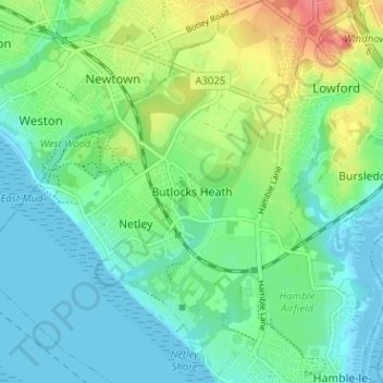
Nom : Carte topographique Butlocks Heath, altitude, relief.

Lieu : Butlocks Heath, Eastleigh, Hampshire, England, SO31 5QJ, United Kingdom (50.85938 -1.35938 50.89938 -1.31938)

Altitude moyenne : 20 m

Altitude minimum : -3 m

Altitude maximum : 67 m

Autres cartes topographiques

Cliquez sur une carte pour visualiser sa topographie, son altitude et son relief.

Eastleigh

United Kingdom > England > Hampshire > Eastleigh

Altitude moyenne : 33 m

West End Copse

United Kingdom > England > Hampshire > Eastleigh > West End

Altitude moyenne : 39 m

Boyatt Wood

United Kingdom > England > Hampshire > Eastleigh > Allbrook

Altitude moyenne : 24 m

West End

United Kingdom > England > Hampshire > Eastleigh > West End

Altitude moyenne : 31 m

Bishopstoke

United Kingdom > England > Hampshire > Eastleigh > Bishopstoke

Altitude moyenne : 25 m

Hatch Grange

United Kingdom > England > Hampshire > Eastleigh > West End

Altitude moyenne : 39 m

Hound

United Kingdom > England > Hampshire > Eastleigh > Butlocks Heath

Altitude moyenne : 19 m

Allbrook

United Kingdom > England > Hampshire > Eastleigh > Allbrook

Altitude moyenne : 37 m

Équipez-vous pour votre prochaine aventure :

🧭Boussoles de randonnée - Boussoles précises pour navigation et orientation sur carte
🧢Casquettes de randonnée - Protection solaire légère pour activités outdoor
🎒Sac à Dos 30 Litres - Volume idéal pour une journée d'exploration topographique
🏮Lanterne de Camping - Éclairage d'ambiance pour le camp de base
🗺️Porte-cartes randonnée - Protection étanche pour cartes papier

En tant que Partenaire Amazon, ce site perçoit une commission sur les achats éligibles sans surcoût pour vous.