
Carte topographique Mowe Lake
Carte interactive
Cliquez sur la carte pour afficher l’altitude.
À propos de cette carte
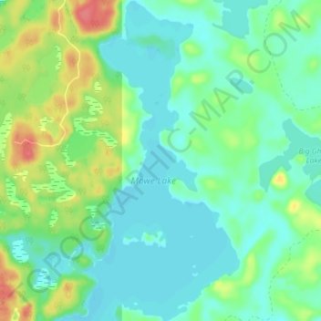
Nom : Carte topographique Mowe Lake, altitude, relief.
Altitude moyenne : 463 m
Altitude minimum : 444 m
Altitude maximum : 509 m
Autres cartes topographiques
Cliquez sur une carte pour visualiser sa topographie, son altitude et son relief.
Stoney Creek
Canada > Ontario > Thunder Bay District > Unorganized Thunder Bay District
Stoney Creek, Unorganized Thunder Bay District, Thunder Bay District, Northwestern Ontario, Ontario, Canada
Altitude moyenne : 367 m
Ombabika River
Canada > Ontario > Thunder Bay District > Unorganized Thunder Bay District
Ombabika River, Unorganized Thunder Bay District, Thunder Bay District, Northwestern Ontario, Ontario, Canada
Altitude moyenne : 311 m
Ara Lake
Canada > Ontario > Thunder Bay District > Unorganized Thunder Bay District
Ara Lake, Unorganized Thunder Bay District, Thunder Bay District, Northwestern Ontario, Ontario, Canada
Altitude moyenne : 308 m
Ara Island
Canada > Ontario > Thunder Bay District > Unorganized Thunder Bay District
Ara Island, Unorganized Thunder Bay District, Thunder Bay District, Northwestern Ontario, Ontario, Canada
Altitude moyenne : 305 m
Davidson Lake
Canada > Ontario > Thunder Bay District > Unorganized Thunder Bay District
Davidson Lake, Unorganized Thunder Bay District, Thunder Bay District, Northwestern Ontario, Ontario, Canada
Altitude moyenne : 292 m
Pringle
Canada > Ontario > Thunder Bay District > Unorganized Thunder Bay District
Pringle, Unorganized Thunder Bay District, Thunder Bay District, Northwestern Ontario, Ontario, Canada
Altitude moyenne : 289 m