
Carte topographique Tybee Island
Carte interactive
Cliquez sur la carte pour afficher l’altitude.
À propos de cette carte
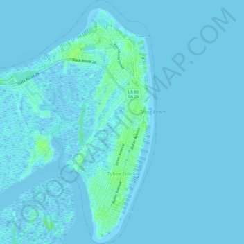
Nom : Carte topographique Tybee Island, altitude, relief.
Lieu : Tybee Island, Chatham County, Georgia, 31328, United States (31.98563 -80.88359 32.03082 -80.83946)
Altitude moyenne : 1 m
Altitude minimum : -4 m
Altitude maximum : 9 m
Autres cartes topographiques
Cliquez sur une carte pour visualiser sa topographie, son altitude et son relief.
Chatham County
United States > Georgia > Chatham County
Chatham County, Georgia, United States
Altitude moyenne : 3 m
Fort Pulaski
United States > Georgia > Chatham County
Fort Pulaski, Fort Perimeter Trail, Chatham County, Georgia, 31328, United States
Altitude moyenne : 1 m
Moon River
United States > Georgia > Chatham County > Burnside View
Moon River, Burnside View, Chatham County, Georgia, 31411, United States
Altitude moyenne : 2 m
Savannah
United States > Georgia > Chatham County
Savannah, Chatham County, Georgia, United States
Altitude moyenne : 4 m