
Carte topographique Leverett
Carte interactive
Cliquez sur la carte pour afficher l’altitude.
À propos de cette carte
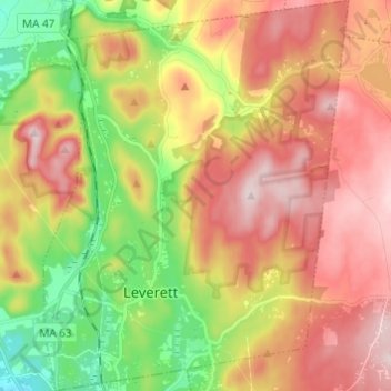
Nom : Carte topographique Leverett, altitude, relief.
Altitude moyenne : 220 m
Altitude minimum : 45 m
Altitude maximum : 384 m
According to the United States Census Bureau, the town has a total area of 23.0 square miles (60 km2), of which 22.9 square miles (59 km2) are land and 0.1-square-mile (0.26 km2) (0.61%) is water. Leverett is located on the edge of the Pioneer Valley and the hills of northwestern Massachusetts, just east of the Connecticut River. The southwestern corner of town is relatively flat plains, while the rest is dominated by hills, the tallest of which is Brushy Mountain, with an elevation of 1,260 feet (380 m).
Autres cartes topographiques
Cliquez sur une carte pour visualiser sa topographie, son altitude et son relief.
Leyden
United States > Massachusetts > Franklin County
Leyden, Franklin County, Massachusetts, United States
Altitude moyenne : 249 m
Conway
United States > Massachusetts > Franklin County
Conway, Franklin County, Massachusetts, 01341, United States
Altitude moyenne : 238 m
Swift River
United States > Massachusetts > Franklin County > Ashfield
Swift River, Ashfield, Franklin County, Massachusetts, 01070, United States
Altitude moyenne : 435 m
Doolittle Brook Conservation Area
United States > Massachusetts > Franklin County > Leverett
Doolittle Brook Conservation Area, Rattlesnake Gutter Road, Leverett, Franklin County, Massachusetts, 01054, United States
Altitude moyenne : 192 m