
Carte topographique City of Gloversville
Carte interactive
Cliquez sur la carte pour afficher l’altitude.
À propos de cette carte
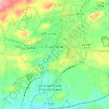
Nom : Carte topographique City of Gloversville, altitude, relief.
Altitude moyenne : 262 m
Altitude minimum : 204 m
Altitude maximum : 376 m
The city sits in the foothills of the Adirondack Mountains and therefore is within a climatic transition zone. Gloversville experiences the warmer summer temperatures common throughout the Capital Region, Hudson Valley, and Mohawk Valley while experiencing generally more copious precipitation throughout the year than the Capital Region. This manifests in commonplace rolling thunderstorms throughout the summer months and snowfall amounts more akin to the lake-pocked higher elevations of the Adirondacks in the winter months.
Autres cartes topographiques
Cliquez sur une carte pour visualiser sa topographie, son altitude et son relief.
Town of Mayfield
United States > New York > Fulton County
Town of Mayfield, Fulton County, New York, 12117, United States
Altitude moyenne : 334 m