
Carte topographique Sitapur
Carte interactive
Cliquez sur la carte pour afficher l’altitude.
À propos de cette carte
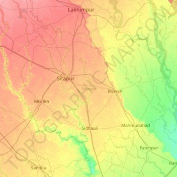
Nom : Carte topographique Sitapur, altitude, relief.
Lieu : Sitapur, Uttar Pradesh, India (27.10146 80.29944 27.90762 81.41530)
Altitude moyenne : 131 m
Altitude minimum : 108 m
Altitude maximum : 158 m
Sitapur is located at 27.57°N 80.68°E. It test has an average elevation of 138 meters (452 feet). It is located in the Gangetic Plain, with elevations ranging from 150 m above sea level in the north-west to 100 m in the south-east. It is intersected by numerous streams and ravines and contains many shallow ponds and natural reservoirs, which overflow during the rainy seasons, but become dry, in some places, in the hot season. Except in the eastern portion, which lies in the doabs between the Kewani and the Chauka, and the Ghaghra and the Chauka rivers, the soil is semi arid. Even this moist tract is interspersed with patches of land covered with saline efflorescence called reh.
Autres cartes topographiques
Cliquez sur une carte pour visualiser sa topographie, son altitude et son relief.
Mountains
Mountains, Kānpur, Kanpur Dehat, Uttar Pradesh, India
Altitude moyenne : 135 m
Jhansi
India > Uttar Pradesh > Jhansi
Jhansi, Jhānsi, Jhansi, Uttar Pradesh, 284001, India
Altitude moyenne : 237 m