
Carte topographique Sixteen Mile Creek
Carte interactive
Cliquez sur la carte pour afficher l’altitude.
À propos de cette carte
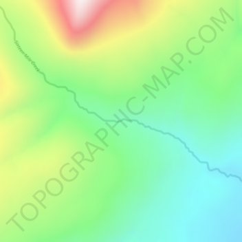
Nom : Carte topographique Sixteen Mile Creek, altitude, relief.
Altitude moyenne : 1 267 m
Altitude minimum : 1 027 m
Altitude maximum : 1 711 m
Autres cartes topographiques
Cliquez sur une carte pour visualiser sa topographie, son altitude et son relief.
Beaver Lake
Canada > British Columbia > Regional District of Kitimat-Stikine > Area F (Dease Lake) > Dease Lake
Beaver Lake, Dease Lake, Area F (Dease Lake), Regional District of Kitimat-Stikine, British Columbia, Canada
Altitude moyenne : 865 m
Dease Lake
Canada > British Columbia > Regional District of Kitimat-Stikine > Area F (Dease Lake)
Dease Lake, Area F (Dease Lake), Regional District of Kitimat-Stikine, British Columbia, V0C 1L0, Canada
Altitude moyenne : 898 m
Ball Creek
Canada > British Columbia > Regional District of Kitimat-Stikine > Area F (Dease Lake)
Ball Creek, Area F (Dease Lake), Regional District of Kitimat-Stikine, British Columbia, Canada
Altitude moyenne : 1 267 m