
Carte topographique Friendswood
Carte interactive
Cliquez sur la carte pour afficher l’altitude.
À propos de cette carte
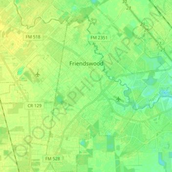
Nom : Carte topographique Friendswood, altitude, relief.
Lieu : Friendswood, Galveston County, Texas, 77546, United States (29.45406 -95.23308 29.57296 -95.14692)
Altitude moyenne : 11 m
Altitude minimum : 2 m
Altitude maximum : 17 m
Autres cartes topographiques
Cliquez sur une carte pour visualiser sa topographie, son altitude et son relief.
Galveston
United States > Texas > Galveston County
Galveston, Galveston County, Texas, United States
Altitude moyenne : 1 m
San Leon
United States > Texas > Galveston County
San Leon, Galveston County, Texas, 77395, United States
Altitude moyenne : 1 m
Hitchcock
United States > Texas > Galveston County
Hitchcock, Galveston County, Texas, 77563, United States
Altitude moyenne : 3 m
Texas City
United States > Texas > Galveston County
Texas City, Galveston County, Texas, United States
Altitude moyenne : 2 m
Galveston
United States > Texas > Galveston County > Galveston
Galveston, Galveston County, Texas, 77553, United States
Altitude moyenne : 1 m
Hitchcock
United States > Texas > Galveston County > Hitchcock > Hitchcock
Hitchcock, Galveston County, Texas, 77563, United States
Altitude moyenne : 5 m
Galveston Island
United States > Texas > Galveston County > Galveston
Galveston Island, Galveston, Galveston County, Texas, 77554, United States
Altitude moyenne : 2 m
Clear Lake
United States > Texas > Galveston County > Kemah
Clear Lake, Kemah, Galveston County, Texas, United States
Altitude moyenne : 5 m
La Marque
United States > Texas > Galveston County
La Marque, Galveston County, Texas, 77568, United States
Altitude moyenne : 4 m
Dickinson
United States > Texas > Galveston County
Dickinson, Galveston County, Texas, 77539, United States
Altitude moyenne : 6 m
League City
United States > Texas > Galveston County > League City
League City, Galveston County, Texas, 77573, United States
Altitude moyenne : 7 m