
Faire un don
Équipez-vous pour votre prochaine aventure :
En tant que Partenaire Amazon, ce site perçoit une commission sur les achats éligibles sans surcoût pour vous.
Carte topographique Cedar Crest
Cliquez sur la carte pour afficher l’altitude.
Faire un don
Équipez-vous pour votre prochaine aventure :
En tant que Partenaire Amazon, ce site perçoit une commission sur les achats éligibles sans surcoût pour vous.
À propos de cette carte
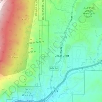
Nom : Carte topographique Cedar Crest, altitude, relief.
Altitude moyenne : 2 125 m
Altitude minimum : 1 905 m
Altitude maximum : 2 644 m
Faire un don
Équipez-vous pour votre prochaine aventure :
En tant que Partenaire Amazon, ce site perçoit une commission sur les achats éligibles sans surcoût pour vous.
Autres cartes topographiques
Cliquez sur une carte pour visualiser sa topographie, son altitude et son relief.
Albuquerque
United States > New Mexico > Bernalillo County
Albuquerque is located in north-central New Mexico. To its east are the Sandia–Manzano Mountains. The Rio Grande flows north to south through its center, while the West Mesa and Petroglyph National Monument make up the western part of the city. Albuquerque has one of the highest elevations of any major city…
Altitude moyenne : 1 671 m
Sandia Mountains Historical Marker
United States > New Mexico > Bernalillo County
Altitude moyenne : 2 938 m
Faire un don
Équipez-vous pour votre prochaine aventure :
En tant que Partenaire Amazon, ce site perçoit une commission sur les achats éligibles sans surcoût pour vous.
Faire un don
Équipez-vous pour votre prochaine aventure :
En tant que Partenaire Amazon, ce site perçoit une commission sur les achats éligibles sans surcoût pour vous.
Eastrange-Piedra Vista
United States > New Mexico > Bernalillo County > Albuquerque
Altitude moyenne : 1 839 m
Albuquerque
United States > New Mexico > Bernalillo County
Albuquerque is located in north-central New Mexico. To its east are the Sandia–Manzano Mountains. The Rio Grande flows north to south through its center, while the West Mesa and Petroglyph National Monument make up the western part of the city. Albuquerque has one of the highest elevations of any major city…
Altitude moyenne : 1 671 m
Faire un don
Équipez-vous pour votre prochaine aventure :
En tant que Partenaire Amazon, ce site perçoit une commission sur les achats éligibles sans surcoût pour vous.
Sandia Crest
United States > New Mexico > Bernalillo County
The Sandias are the highest range in the immediate vicinity, and are well-separated from the higher Sangre de Cristo Mountains. This gives Sandia Crest a relatively high topographic prominence of 4,098 ft (1,249 m). Lying to the east and northeast of the Sandias are two smaller ranges, the Ortiz Mountains and…
Altitude moyenne : 2 925 m
Albuquerque
United States > New Mexico > Bernalillo County
Albuquerque is located in north-central New Mexico. To its east are the Sandia–Manzano Mountains. The Rio Grande flows north to south through its center, while the West Mesa and Petroglyph National Monument make up the western part of the city. Albuquerque has one of the highest elevations of any major city…
Altitude moyenne : 1 671 m
Vista Del Mundo
United States > New Mexico > Bernalillo County > Albuquerque
Altitude moyenne : 1 903 m
Albuquerque
United States > New Mexico > Bernalillo County
Albuquerque is located in north-central New Mexico. To its east are the Sandia–Manzano Mountains. The Rio Grande flows north to south through its center, while the West Mesa and Petroglyph National Monument make up the western part of the city. Albuquerque has one of the highest elevations of any major city…
Altitude moyenne : 1 671 m
Faire un don
Équipez-vous pour votre prochaine aventure :
En tant que Partenaire Amazon, ce site perçoit une commission sur les achats éligibles sans surcoût pour vous.
Sandia Heights
United States > New Mexico > Bernalillo County > Albuquerque
Altitude moyenne : 1 898 m
Faire un don
Équipez-vous pour votre prochaine aventure :
En tant que Partenaire Amazon, ce site perçoit une commission sur les achats éligibles sans surcoût pour vous.
Winterwood Park (HOA)
United States > New Mexico > Bernalillo County > Albuquerque
Altitude moyenne : 1 770 m
Monte Largo Hills
United States > New Mexico > Bernalillo County > Albuquerque
Altitude moyenne : 1 817 m
Faire un don
Équipez-vous pour votre prochaine aventure :
En tant que Partenaire Amazon, ce site perçoit une commission sur les achats éligibles sans surcoût pour vous.
Faire un don
Équipez-vous pour votre prochaine aventure :
En tant que Partenaire Amazon, ce site perçoit une commission sur les achats éligibles sans surcoût pour vous.
Glenwood Hills
United States > New Mexico > Bernalillo County > Albuquerque
Altitude moyenne : 1 937 m
Joe M. Lucero Hillside
United States > New Mexico > Bernalillo County > Albuquerque
Altitude moyenne : 1 637 m