
Carte topographique Malaspina Glacier
Carte interactive
Cliquez sur la carte pour afficher l’altitude.
Malaspina Glacier
The Malaspina is up to 600 meters (2,000 ft) thick in places, with the elevation of its bottom being estimated to be as much as 300 m (980 ft) below sea level.[4] There are two lakes on its margins: Oily Lake to the northwest, at the foot of the Samovar Hills between the Agassiz and Seward glaciers, and Malaspina Lake to the southeast, close to Yakutat Bay.
À propos de cette carte
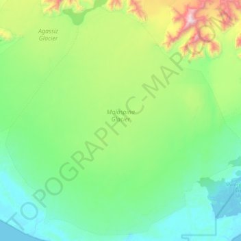
Nom : Carte topographique Malaspina Glacier, altitude, relief.
Lieu : Malaspina Glacier, Yakutat, Alaska, United States (59.74222 -140.95854 60.13048 -140.14049)
Altitude moyenne : 393 m
Altitude minimum : -3 m
Altitude maximum : 2 086 m
Autres cartes topographiques
Cliquez sur une carte pour visualiser sa topographie, son altitude et son relief.
Hubbard Glacier
United States > Alaska > Yakutat
The longest source for Hubbard Glacier originates 122 kilometres (76 mi) from its snout and is located at about 61°00′N 140°09′W / 61.000°N 140.150°W / 61.000; -140.150, approximately 8 kilometres (5 mi) west of Mount Walsh with an elevation around 3,400 metres (11,200 ft). A shorter tributary…
Altitude moyenne : 1 892 m