
Carte topographique Snake River
Carte interactive
Cliquez sur la carte pour afficher l’altitude.
À propos de cette carte
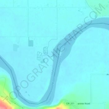
Nom : Carte topographique Snake River, altitude, relief.
Lieu : Snake River, Washington County, Idaho, United States (44.23865 -117.04475 44.24356 -117.04113)
Altitude moyenne : 643 m
Altitude minimum : 635 m
Altitude maximum : 726 m
Mountain ranges in the Snake watershed include the Teton Range, Bitterroot Range, Clearwater Mountains, Seven Devils Mountains, and the extreme northwestern end of the Wind River Range. Grand Teton is the highest point in the Snake River watershed, reaching 13,775 feet (4,199 m) in elevation. The elevation of the Snake River is 358 feet (109 m) when it joins the Columbia River.
Autres cartes topographiques
Cliquez sur une carte pour visualiser sa topographie, son altitude et son relief.
Snake River
United States > Idaho > Washington County
Snake River, Washington County, Idaho, United States
Altitude moyenne : 643 m
Snake River
United States > Idaho > Washington County
Snake River, Washington County, Idaho, 83672, United States
Altitude moyenne : 644 m