
Carte topographique Higdon
Carte interactive
Cliquez sur la carte pour afficher l’altitude.
À propos de cette carte
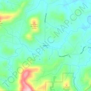
Nom : Carte topographique Higdon, altitude, relief.
Lieu : Higdon, Fannin County, Georgia, 30541, United States (34.87647 -84.45881 34.91647 -84.41881)
Altitude moyenne : 595 m
Altitude minimum : 522 m
Altitude maximum : 807 m
Autres cartes topographiques
Cliquez sur une carte pour visualiser sa topographie, son altitude et son relief.
Blue Ridge
United States > Georgia > Fannin County
Blue Ridge, Fannin County, Georgia, United States
Altitude moyenne : 535 m
Wilscot
United States > Georgia > Fannin County
Wilscot, Fannin County, Georgia, United States
Altitude moyenne : 614 m
Aska
United States > Georgia > Fannin County
Aska, Fannin County, Georgia, United States
Altitude moyenne : 629 m
Greens Mill
United States > Georgia > Fannin County
Greens Mill, Fannin County, Georgia, 30513, United States
Altitude moyenne : 566 m
Dial
United States > Georgia > Fannin County
Dial, Fannin County, Georgia, United States
Altitude moyenne : 612 m
Colwell
United States > Georgia > Fannin County
Colwell, Fannin County, Georgia, United States
Altitude moyenne : 630 m
Lake Blue Ridge
United States > Georgia > Fannin County > Morganton
Lake Blue Ridge, Morganton, Fannin County, Georgia, United States
Altitude moyenne : 572 m
Cordell Mountain
United States > Georgia > Fannin County
Cordell Mountain, Fannin County, Georgia, 30559, United States
Altitude moyenne : 601 m
Springer Mountain
United States > Georgia > Fannin County
Springer Mountain, Fannin County, Georgia, United States
Altitude moyenne : 941 m
Ocoee River
United States > Georgia > Fannin County
Ocoee River, Fannin County, East Tennessee, Georgia, 30572, United States
Altitude moyenne : 579 m
McCaysville
United States > Georgia > Fannin County
McCaysville, Fannin County, Georgia, United States
Altitude moyenne : 484 m
Morganton
United States > Georgia > Fannin County
Morganton, Fannin County, Georgia, United States
Altitude moyenne : 538 m
Mineral Bluff
United States > Georgia > Fannin County
Mineral Bluff, Fannin County, Georgia, 30559, United States
Altitude moyenne : 516 m
Kyle
United States > Georgia > Fannin County
Kyle, Fannin County, Georgia, 30555, United States
Altitude moyenne : 508 m
Epworth
United States > Georgia > Fannin County > Epworth
Epworth, Fannin County, Georgia, 30555, United States
Altitude moyenne : 524 m
Loving
United States > Georgia > Fannin County > Loving
Loving, Fannin County, Georgia, 30560, United States
Altitude moyenne : 577 m