
Carte topographique Welshpool
Carte interactive
Cliquez sur la carte pour afficher l’altitude.
À propos de cette carte
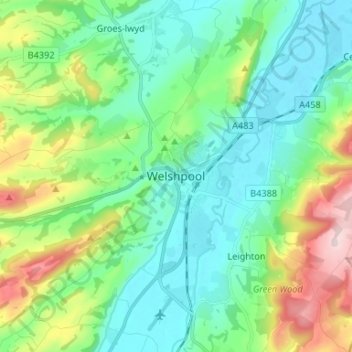
Nom : Carte topographique Welshpool, altitude, relief.
Lieu : Welshpool, Powys, Wales, SY21 7SD, United Kingdom (52.62007 -3.18742 52.70007 -3.10742)
Altitude moyenne : 156 m
Altitude minimum : 63 m
Altitude maximum : 412 m
The Mermaid Inn, 28 High Street, was very probably an early 16th-century merchant's house, placed on a burgage plot between the High Street and Alfred Jones Court. The timber-framed building has long storehouse or wing to the rear. The frontage was remodelled c. 1890, by Frank H. Shayler, architect, of Shrewsbury. Early illustrations of the building show that prior to this it had a thatched roof and that the timbering was not exposed. There is a passage to side with heavy box-framing in square panels, with brick infill exposed in side elevation and in rear wing. The frontage was exposed by Shayler to show decorative timber work on the upper storey. An Inn by the 19th century when it was owned by a family named Sparrow.
Autres cartes topographiques
Cliquez sur une carte pour visualiser sa topographie, son altitude et son relief.
Cascob
United Kingdom > Wales > Powys
Cascob, Whitton, Powys, Wales, LD8 2NT, United Kingdom
Altitude moyenne : 293 m
Llangunllo
United Kingdom > Wales > Powys > Llangunllo
Llangunllo, Powys, Wales, United Kingdom
Altitude moyenne : 332 m
Black Mountains
United Kingdom > Wales > Powys > Craswall
Black Mountains, Craswall, Powys, Wales, NP7 7NP, United Kingdom
Altitude moyenne : 373 m
Heol-fanog
United Kingdom > Wales > Powys
Heol-fanog, Glyn Tarell, Powys, Wales, LD3 8LE, United Kingdom
Altitude moyenne : 296 m