
Faire un don
Équipez-vous pour votre prochaine aventure :
En tant que Partenaire Amazon, ce site perçoit une commission sur les achats éligibles sans surcoût pour vous.
Carte topographique Tequila
Cliquez sur la carte pour afficher l’altitude.
Faire un don
Équipez-vous pour votre prochaine aventure :
En tant que Partenaire Amazon, ce site perçoit une commission sur les achats éligibles sans surcoût pour vous.
Tequila
Tequila is one of the 124 municipalities of Jalisco, located just west of the center of the state. Its territory extends for 1689.11km2, with elevations that vary between 700 and 2,900 meters above sea level. The municipality borders with the main metropolitan region of Guadalajara to the east (Zapopan), and the State of Zacatecas to the north. All of the neighboring municipalities surrounding Mount Tequila conform the greater region of 'Tequila'. These include the adjacent municipalities of Amatitlán, Magdalena, San Juanito de Escobedo, San Martín de Bolaños, San Cristóbal de la Barranca, Hostotipaquillo and, south of Tequila Volcano: Teuchtilán and Ahualulco de Mercado. The original land-subdivision of the region was delineated by the Agave-growing haciendas that are found throughout.
Faire un don
Équipez-vous pour votre prochaine aventure :
En tant que Partenaire Amazon, ce site perçoit une commission sur les achats éligibles sans surcoût pour vous.
À propos de cette carte
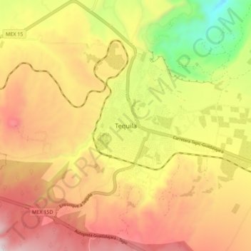
Nom : Carte topographique Tequila, altitude, relief.
Lieu : Tequila, Región Valles, Jalisco, Mexico (20.84212 -103.87709 20.92212 -103.79709)
Altitude moyenne : 1 267 m
Altitude minimum : 690 m
Altitude maximum : 1 749 m
Faire un don
Équipez-vous pour votre prochaine aventure :
En tant que Partenaire Amazon, ce site perçoit une commission sur les achats éligibles sans surcoût pour vous.
Autres cartes topographiques
Cliquez sur une carte pour visualiser sa topographie, son altitude et son relief.