
Carte topographique Jaffrey
Carte interactive
Cliquez sur la carte pour afficher l’altitude.
Jaffrey
Thorndike Pond is in the north, and Contoocook Lake is on the southern boundary. Mount Monadnock, elevation 3,165 feet (965 m) and the highest point in Jaffrey as well as Cheshire County, is in the northwest. Jaffrey lies mostly within the Merrimack River watershed, via the Contoocook River in the eastern part of the town, with the northwest corner of town lying in the Ashuelot River watershed, part of the larger Connecticut River watershed.
À propos de cette carte
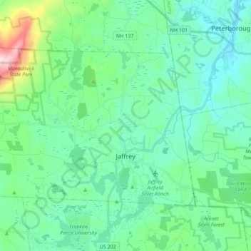
Nom : Carte topographique Jaffrey, altitude, relief.
Altitude moyenne : 351 m
Altitude minimum : 216 m
Altitude maximum : 940 m