
Carte topographique Catang Island
Carte interactive
Cliquez sur la carte pour afficher l’altitude.
À propos de cette carte
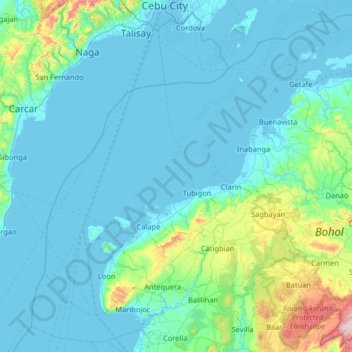
Nom : Carte topographique Catang Island, altitude, relief.
Altitude moyenne : 79 m
Altitude minimum : -3 m
Altitude maximum : 715 m
Autres cartes topographiques
Cliquez sur une carte pour visualiser sa topographie, son altitude et son relief.
Loboc River
Philippines > Bohol > Tagbilaran
Loboc River, Tagbilaran, Bohol, Central Visayas, Philippines
Altitude moyenne : 199 m
Loboc River
Philippines > Bohol > Tagbilaran
Loboc River, Tagbilaran, Bohol, Central Visayas, 6316, Philippines
Altitude moyenne : 28 m
Cancostino Island
Philippines > Bohol > Tagbilaran
Cancostino Island, Tagbilaran, Bohol, Central Visayas, 6329, Philippines
Altitude moyenne : 89 m
Cabgan Islet
Philippines > Bohol > Tagbilaran
Cabgan Islet, Tagbilaran, Bohol, Central Visayas, 6329, Philippines
Altitude moyenne : 90 m
Cabilao Island
Philippines > Bohol > Tagbilaran
Cabilao Island, Tagbilaran, Bohol, Central Visayas, Philippines
Altitude moyenne : 6 m
Mantatao Island
Philippines > Bohol > Tagbilaran
Mantatao Island, Tagbilaran, Bohol, Central Visayas, Philippines
Altitude moyenne : 0 m
Silo Island
Philippines > Bohol > Tagbilaran
Silo Island, Tagbilaran, Bohol, Central Visayas, 6330, Philippines
Altitude moyenne : 90 m
Sandingan Island
Philippines > Bohol > Tagbilaran
Sandingan Island, Tagbilaran, Bohol, Central Visayas, Philippines
Altitude moyenne : 10 m