
Carte topographique Alfred and Plantagenet
Carte interactive
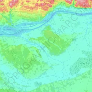
Cliquez sur la carte pour afficher l’altitude.
À propos de cette carte
Nom : Carte topographique Alfred and Plantagenet, altitude, relief.
Altitude moyenne : 71 m
Altitude minimum : 38 m
Altitude maximum : 260 m
Autres cartes topographiques
Cliquez sur une carte pour visualiser sa topographie, son altitude et son relief.
Embrun
Canada > Ontario > Prescott and Russell Counties
Embrun, Russell, Prescott and Russell Counties, Eastern Ontario, Ontario, K0A 1W1, Canada
Altitude moyenne : 69 m
Voyageur Provincial Park
Canada > Ontario > Prescott and Russell Counties > East Hawkesbury
Voyageur Provincial Park, East Hawkesbury, Prescott and Russell Counties, Eastern Ontario, Ontario, K0B 1B0, Canada
Altitude moyenne : 45 m
Limoges
Canada > Ontario > Prescott and Russell Counties > The Nation > Limoges
Limoges, The Nation, Prescott and Russell Counties, Eastern Ontario, Ontario, K0A 2M0, Canada
Altitude moyenne : 71 m
St-Eugène
Canada > Ontario > Prescott and Russell Counties > East Hawkesbury > St-Eugène
St-Eugène, East Hawkesbury, Prescott and Russell Counties, Eastern Ontario, Ontario, K0B 1P0, Canada
Altitude moyenne : 59 m
Clarence-Rockland
Canada > Ontario > Prescott and Russell Counties > Clarence-Rockland
Clarence-Rockland, Prescott and Russell Counties, Eastern Ontario, Ontario, Canada
Altitude moyenne : 71 m
The Nation
Canada > Ontario > Prescott and Russell Counties > The Nation
The Nation, Prescott and Russell Counties, Eastern Ontario, Ontario, Canada
Altitude moyenne : 72 m
Hawkesbury
Canada > Ontario > Prescott and Russell Counties
Hawkesbury, Prescott and Russell Counties, Eastern Ontario, Ontario, Canada
Altitude moyenne : 52 m