
Carte topographique Similaun
Carte interactive
Cliquez sur la carte pour afficher l’altitude.
À propos de cette carte
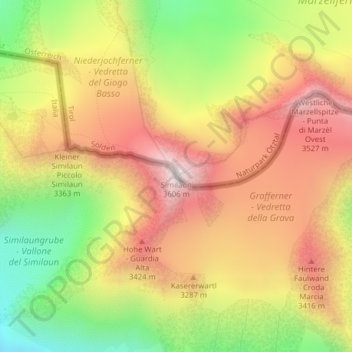
Nom : Carte topographique Similaun, altitude, relief.
Altitude moyenne : 3 166 m
Altitude minimum : 2 693 m
Altitude maximum : 3 575 m
Autres cartes topographiques
Cliquez sur une carte pour visualiser sa topographie, son altitude et son relief.
Kurzras - Maso Corto
Italy > Trentino-Alto Adige/Südtirol > South Tyrol > Schnals - Senales
Kurzras - Maso Corto, Schnals - Senales, Vinschgau - Val Venosta, South Tyrol, Trentino-Alto Adige/Südtirol, Italy
Altitude moyenne : 2 457 m