
Carte topographique Malitbog
Carte interactive
Cliquez sur la carte pour afficher l’altitude.
À propos de cette carte
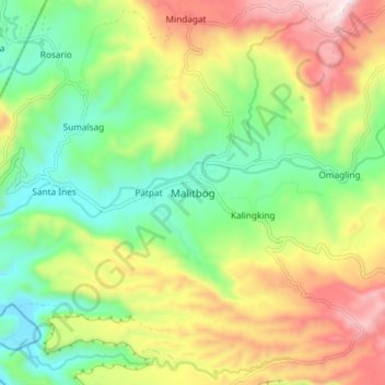
Nom : Carte topographique Malitbog, altitude, relief.
Lieu : Malitbog, Bukidnon, Northern Mindanao, Philippines (8.49289 124.84010 8.57289 124.92010)
Altitude moyenne : 343 m
Altitude minimum : 34 m
Altitude maximum : 797 m
Being naturally characterized by mountains and hilly terrain, slope ranging from 30 to 50 percent and above are therefore the most prevalent category. These are the steep to very steep slope found mostly in mountains areas. The largest part which can be found at the north and north-eastern part having an elevation of 1,000 to 1,500 meters above the sea level. Smaller portion at the northern part has the highest elevation of 1,500 to 2,400 meters above sea level. Erosion maps shows that slight to moderate erosion can be found in this area. From Barangay San Luis and Kiabo going south-western part, it has patches of slope 30 to 50 percent and above with an elevation 200 to 1,000 meters above sea level. Major portion of this area has a severe erosion only small area have the slight erosion based on thematic map.