
Carte topographique Grasberg
Carte interactive
Cliquez sur la carte pour afficher l’altitude.
À propos de cette carte
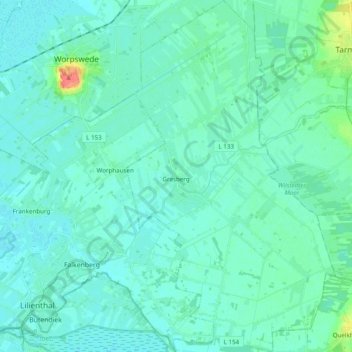
Nom : Carte topographique Grasberg, altitude, relief.
Lieu : Grasberg, Landkreis Osterholz, Lower Saxony, 28879, Germany (53.12596 8.95577 53.24226 9.07135)
Altitude moyenne : 7 m
Altitude minimum : 0 m
Altitude maximum : 51 m
Autres cartes topographiques
Cliquez sur une carte pour visualiser sa topographie, son altitude et son relief.
Hüttenbusch
Germany > Lower Saxony > Landkreis Osterholz > Worpswede
Hüttenbusch, Worpswede, Landkreis Osterholz, Lower Saxony, 27726, Germany
Altitude moyenne : 5 m
Osterholz-Scharmbeck
Germany > Lower Saxony > Landkreis Osterholz
Osterholz-Scharmbeck, Landkreis Osterholz, Lower Saxony, 27711, Germany
Altitude moyenne : 18 m