
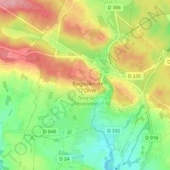
Carte topographique La Prise Tarot
Carte interactive
Cliquez sur la carte pour afficher l’altitude.
À propos de cette carte
Nom : Carte topographique La Prise Tarot, altitude, relief.
Altitude moyenne : 194 m
Altitude minimum : 143 m
Altitude maximum : 254 m
Autres cartes topographiques
Cliquez sur une carte pour visualiser sa topographie, son altitude et son relief.
Les Milles Mottes
France > Normandie > Orne > Bagnoles-de-l'Orne-Normandie > Bagnoles-de-l'Orne
Les Milles Mottes, Bagnoles-de-l'Orne, Bagnoles-de-l'Orne-Normandie, Alençon, Orne, Normandie, France métropolitaine, 61140, France
Altitude moyenne : 191 m
Loup Pendu
France > Normandie > Orne > Bagnoles-de-l'Orne-Normandie > Bagnoles-de-l'Orne
Loup Pendu, Bagnoles-de-l'Orne, Bagnoles-de-l'Orne-Normandie, Alençon, Orne, Normandie, France métropolitaine, 61140, France
Altitude moyenne : 190 m