
Carte topographique Malone Lower
Carte interactive
Cliquez sur la carte pour afficher l’altitude.
À propos de cette carte
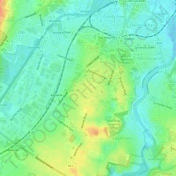
Nom : Carte topographique Malone Lower, altitude, relief.
Altitude moyenne : 15 m
Altitude minimum : -2 m
Altitude maximum : 43 m
Autres cartes topographiques
Cliquez sur une carte pour visualiser sa topographie, son altitude et son relief.
Forth River
United Kingdom > Northern Ireland > Belfast
Forth River, Belfast, County Antrim, Northern Ireland, BT13 3BU, United Kingdom
Altitude moyenne : 73 m