
Carte topographique Ravangla
Carte interactive
Cliquez sur la carte pour afficher l’altitude.
Ravangla
Ravangla or Rawangla or Ravongla is a small tourist town situated at an elevation of 8000 ft in South Sikkim district of the Indian state of Sikkim. It is connected by state highway to other major towns in the state and lies between Pelling and Gangtok. It acts as the starting point for the trek to Maenam Wildlife Sanctuary. It is approximately 65 km away from the state capital Gangtok and 120 km away from Siliguri, West Bengal.
À propos de cette carte
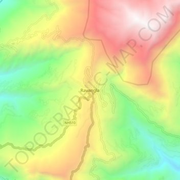
Nom : Carte topographique Ravangla, altitude, relief.
Lieu : Ravangla, Ravong, South Sikkim District, Sikkim, India (27.26513 88.32447 27.34513 88.40447)
Altitude moyenne : 1 870 m
Altitude minimum : 682 m
Altitude maximum : 3 229 m