
Carte topographique Campbellford
Carte interactive
Cliquez sur la carte pour afficher l’altitude.
À propos de cette carte
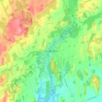
Nom : Carte topographique Campbellford, altitude, relief.
Altitude moyenne : 174 m
Altitude minimum : 123 m
Altitude maximum : 251 m
Autres cartes topographiques
Cliquez sur une carte pour visualiser sa topographie, son altitude et son relief.
Healey Falls
Canada > Ontario > Northumberland County > Trent Hills
Healey Falls, Trent Hills, Northumberland County, Central Ontario, Ontario, Canada
Altitude moyenne : 190 m