
Faire un don
Équipez-vous pour votre prochaine aventure :
En tant que Partenaire Amazon, ce site perçoit une commission sur les achats éligibles sans surcoût pour vous.
Carte topographique Reichenbach im Kandertal
Cliquez sur la carte pour afficher l’altitude.
Faire un don
Équipez-vous pour votre prochaine aventure :
En tant que Partenaire Amazon, ce site perçoit une commission sur les achats éligibles sans surcoût pour vous.
À propos de cette carte
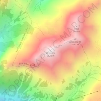
Nom : Carte topographique Reichenbach im Kandertal, altitude, relief.
Altitude moyenne : 1 906 m
Altitude minimum : 1 185 m
Altitude maximum : 2 495 m
Faire un don
Équipez-vous pour votre prochaine aventure :
En tant que Partenaire Amazon, ce site perçoit une commission sur les achats éligibles sans surcoût pour vous.
Autres cartes topographiques
Cliquez sur une carte pour visualiser sa topographie, son altitude et son relief.
Kandersteg
Switzerland > Bern > Frutigen-Niedersimmental administrative district
Kandersteg is located on the northern side of the Bernese Alps at an altitude of 1,200 meters (3,900 ft) above sea level at the foot of the Lötschen and Gemmi Passes. The village, with 1200 inhabitants, lies in the upper Kander Valley. The municipality extends over a territory encompassing the valleys of…
Altitude moyenne : 2 131 m
Adelboden
Switzerland > Bern > Frutigen-Niedersimmental administrative district
Altitude moyenne : 1 962 m
Kandergrund
Switzerland > Bern > Frutigen-Niedersimmental administrative district
Altitude moyenne : 1 553 m
Kiental
Switzerland > Bern > Frutigen-Niedersimmental administrative district > Reichenbach im Kandertal
Since 1910, the nearby mountain of Niesen (altitude 2,362 m [7,749 ft]) can be ascended at gradients of up to 68% via the Niesenbahn, which with a length of 3,499 m (11,480 ft) is the longest funicular railway in Europe.
Altitude moyenne : 1 509 m
Faire un don
Équipez-vous pour votre prochaine aventure :
En tant que Partenaire Amazon, ce site perçoit une commission sur les achats éligibles sans surcoût pour vous.
Kandersteg
Switzerland > Bern > Frutigen-Niedersimmental administrative district
Kandersteg is located on the northern side of the Bernese Alps at an altitude of 1,200 meters (3,900 ft) above sea level at the foot of the Lötschen and Gemmi Passes. The village, with 1200 inhabitants, lies in the upper Kander Valley. The municipality extends over a territory encompassing the valleys of…
Altitude moyenne : 2 131 m
Oeschinen Lake
Switzerland > Bern > Frutigen-Niedersimmental administrative district > Kandersteg
Oeschinen Lake (German: Oeschinensee) is a lake in the Bernese Oberland, Switzerland, 4 kilometres (2.5 mi) east of Kandersteg in the Oeschinen valley. At an elevation of 1,578 metres (5,177 ft), it has a surface area of 1.1147 square kilometres (0.4304 sq mi). Its maximum depth is 56 metres (184 ft).
Altitude moyenne : 1 918 m
Adelboden
Switzerland > Bern > Frutigen-Niedersimmental administrative district
Altitude moyenne : 1 962 m
Faire un don
Équipez-vous pour votre prochaine aventure :
En tant que Partenaire Amazon, ce site perçoit une commission sur les achats éligibles sans surcoût pour vous.
Reichenbach im Kandertal
Switzerland > Bern > Frutigen-Niedersimmental administrative district
Since 1910, the nearby mountain of Niesen (altitude 2,362 m [7,749 ft]) can be ascended at gradients of up to 68% via the Niesenbahn, which with a length of 3,499 m (11,480 ft) is the longest funicular railway in Europe.
Altitude moyenne : 1 759 m
Blausee
Switzerland > Bern > Frutigen-Niedersimmental administrative district > Kandergrund > Blausee-Mitholz
Altitude moyenne : 1 266 m
Diemtigen
Switzerland > Bern > Frutigen-Niedersimmental administrative district
Altitude moyenne : 1 445 m
Frutigen
Switzerland > Bern > Frutigen-Niedersimmental administrative district
Altitude moyenne : 1 505 m
Faire un don
Équipez-vous pour votre prochaine aventure :
En tant que Partenaire Amazon, ce site perçoit une commission sur les achats éligibles sans surcoût pour vous.
Oberwil im Simmental
Switzerland > Bern > Frutigen-Niedersimmental administrative district
Altitude moyenne : 1 395 m